Property Record
545 E Monroe St, Dundee, MI 48131

Save to a Folder
{{folder.Name}}
{{folder.ListingIds.length}} Properties
{{folder.ListingIds.length}} Property
Create a New Folder
Property Detail
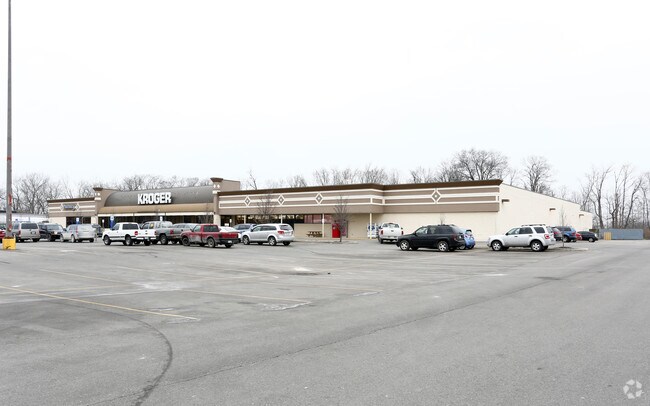
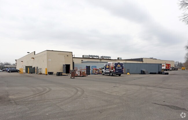
545 E Monroe St
42-040-430-00
SEC 13 T6S R7E 5.50 AMOL COM AT INT OF CL OF M-50 & N & S 1/4 LI OF SEC 19 TH N 682.26 FT TH N 82 DEG 14'E 353.86 FT TH S 0
Wholesaleoutletdiscountstore
Monroe
AE The base floodplain where base flood elevations are provided. AE Zones are now used on new format FIRMs instead of A1-A30 Zones.
Michigan
2025
5.50 AC
2025
Monroe County
830801
Detroit
14,514 SF
Monroe, MI
NEARBY LISTINGS FOR SALE OR LEASE
DEMOGRAPHICS near 545 E Monroe St
1 mile
3 mile
5 mile
2025 Total Population
3,451
8,086
12,601
2030 Population
3,538
8,245
12,751
Pop Growth 2025-2030
+ 2.52%
+ 1.97%
+ 1.19%
Average Age
37
39
40
2025 Total Households
1,296
3,259
4,950
HH Growth 2025-2030
+ 2.55%
+ 2.09%
+ 1.31%
Median Household Inc
$88,937
$79,131
$83,634
Avg Household Size
2.60
2.50
2.50
2025 Avg HH Vehicles
2.00
2.00
2.00
Median Home Value
$290,457
$292,915
$288,781
Median Year Built
1995
1990
1976
Nearby Places
Map Layers
Map Styles
 Street
 Aerial
Layers
 Traffic
 Biking
Places
Listings with unknown addresses are not visible on the map
- Restaurants
- Banks
- Shops
- Fitness
- Groceries
PUBLIC TRANSPORTATION
AIRPORT
Eugene F Kranz Toledo Express
Drive
Walk
Distance
Eugene F Kranz Toledo Express
54 min
37.2 mi
Detroit Metro Wayne County
Drive
Walk
Distance
Detroit Metro Wayne County
52 min
42.0 mi
SALE & LEASE HISTORY
LISTING DATE
SALE/LEASE

Jul 19, 2019
For Lease
Jul 18, 2019
For Sale
Nearby Properties
Address
Land Use
TOTAL SIZE
Lot Size
Zoning
Address
Land Use
TOTAL SIZE
Lot Size
Zoning
676,189 SF
148.70 AC
Address
Land Use
TOTAL SIZE
Lot Size
Zoning
87.22 AC
Address
Land Use
TOTAL SIZE
Lot Size
Zoning
617,380 SF
93.35 AC
Address
Land Use
TOTAL SIZE
Lot Size
Zoning
137,259 SF
9.20 AC
Address
Land Use
TOTAL SIZE
Lot Size
Zoning
150,569 SF
11.16 AC
Address
Land Use
TOTAL SIZE
Lot Size
Zoning
60,934 SF
2.60 AC
Address
Land Use
TOTAL SIZE
Lot Size
Zoning
Address
Land Use
TOTAL SIZE
Lot Size
Zoning
Address
Land Use
TOTAL SIZE
Lot Size
Zoning
100,070 SF
6.77 AC
Address
Land Use
TOTAL SIZE
Lot Size
Zoning
135,300 SF
9.25 AC
Address
Land Use
TOTAL SIZE
Lot Size
Zoning
90,136 SF
3.60 AC
Address
Land Use
TOTAL SIZE
Lot Size
Zoning
95,940 SF
9.57 AC
Address
Land Use
TOTAL SIZE
Lot Size
Zoning
30,520 SF
5 AC
Address
Land Use
TOTAL SIZE
Lot Size
Zoning
48,280 SF
8.40 AC
Address
Land Use
TOTAL SIZE
Lot Size
Zoning
Address
Land Use
TOTAL SIZE
Lot Size
Zoning
16,301 SF
5.83 AC
Address
Land Use
TOTAL SIZE
Lot Size
Zoning
39,814 SF
3.04 AC
Address
Land Use
TOTAL SIZE
Lot Size
Zoning
73,168 SF
21.32 AC
Address
Land Use
TOTAL SIZE
Lot Size
Zoning
74,000 SF
52.40 AC
Address
Land Use
TOTAL SIZE
Lot Size
Zoning
20,504 SF
14.89 AC
Address
Land Use
TOTAL SIZE
Lot Size
Zoning
91,219 SF
9.94 AC
Address
Land Use
TOTAL SIZE
Lot Size
Zoning
31,180 SF
3.39 AC
Address
Land Use
TOTAL SIZE
Lot Size
Zoning
Address
Land Use
TOTAL SIZE
Lot Size
Zoning
46,943 SF
6.29 AC
Address
Land Use
TOTAL SIZE
Lot Size
Zoning
58,734 SF
13.36 AC
Address
Land Use
TOTAL SIZE
Lot Size
Zoning
24,800 SF
2.89 AC
Address
Land Use
TOTAL SIZE
Lot Size
Zoning
48,628 SF
7.95 AC
Address
Land Use
TOTAL SIZE
Lot Size
Zoning
43,869 SF
3.15 AC
Address
Land Use
TOTAL SIZE
Lot Size
Zoning
22,388 SF
4.38 AC
Address
Land Use
TOTAL SIZE
Lot Size
Zoning
43,489 SF
3.61 AC
The World's #1 Commercial Real Estate Marketplace
Connect with us
© 2026 CoStar Group
The information above has been obtained from sources believed reliable. While we do not doubt its accuracy we have not verified it and make no guarantee, warranty or representation about it. It is your responsibility to independently confirm its accuracy and completeness. Any projections, opinions, assumptions, or estimates used are for example only and do not represent the current or future performance of the property. The value of this transaction to you depends on tax and other factors which should be evaluated by your tax, financial, and legal advisors. You and your advisors should conduct a careful, independent investigation of the property to determine to your satisfaction the suitability of the property for your needs.